

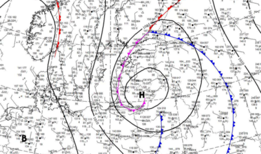
The North Atlantic cyclone Bernadette, which has been affecting Belarus's weather for the past two days, has brought cool weather with heavy precipitation and gusty winds. The brunt of the storm hit on July 8 (Wednesday), when an orange hazard level was declared due to strong gusty winds. Today, July 9, the cyclone's center is located over the Baltic countries, and tomorrow, July 10, it will shift to the western regions of our country. Filling with cold air, the atmospheric vortex will gradually lose its intensity.
As a result, cloudy and rainy weather will persist across the republic until the end of this week. Under the influence of atmospheric fronts from Cyclone Bernadette, rains of varying intensity will occur in most regions of the country. During the daytime on July 11-12 (Saturday-Sunday), precipitation will locally reach the criteria for heavy rain. With the development of convective clouds, thunderstorms are expected in some areas of the country. At the same time, due to the advection of cooler air masses, nighttime lows will range from +7 +9°C to +13 +15°C, while daytime highs will vary from +16°C in the west to +25°C in the east.
Subsequently, the North Atlantic cyclone will merge with the Caspian cyclone, forming an extensive cyclonic depression centered over the European territory of Russia. The cloudy vortex formed by this regeneration will continue to deliver new rounds of precipitation to our country in the first days of the coming week, while also paving the way for warmer air masses. After that, an anticyclone from Western Europe will begin to improve the situation, reducing cloud cover and precipitation. Thus, the damp autumn-like weather will give way to summer warmth returning to Belarus.
© Belhydromet, 2016-2026