

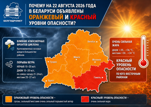
Over the next 24 hours, on August 22, unstable weather conditions are expected in Belarus. Under the influence of atmospheric fronts from a cyclone moving from the territory of Poland towards the Baltic countries, brief thunderstorm rains will occur in most areas. At night, squally wind gusts of 15-20 m/s are expected in some areas during thunderstorms, while during the day, as baric gradients increase, winds will strengthen across most of the territory with gusts of 15-20 m/s; in the northwest, gusts may reach 21-24 m/s, and in some areas, very strong gusty winds with maximum speeds of 25-27 m/s cannot be ruled out. Due to the expected adverse hydrometeorological phenomena (thunderstorms, strong/occasionally very strong gusty winds), an orange hazard level has been declared for August 22 (Saturday) over most of the country.
In addition, the frontal boundary will cause temperature contrasts across the republic: daytime maximums will range from +19°C in the northwest to +36°C in the southeast. Given that during the daytime hours on Saturday, maximum air temperatures in the southeastern regions of the republic will reach +35 +36°C, and in some areas +30 +34°C, a storm warning has been issued for extreme heat (red hazard level).
On August 23 (Sunday), the cyclone center will move to the northwestern regions of the European territory of Russia, and Belarus will find itself in its cold and windy rear sector. Gradually, the influence of atmospheric fronts will weaken, and with rising atmospheric pressure, precipitation will become less intense and more localized. The temperature background will decrease: nighttime temperatures will range from +9 to +14°C, and daytime temperatures will be +18 to +25°C.
In the following days (August 24-27), due to continued advection of air masses from northwestern Europe, the republic will maintain cool weather, with temperatures generally 1-4°C below the long-term average values. At the same time, with a higher background of atmospheric pressure, little precipitation is expected; only on some days, in unstable air, cumulonimbus clouds will develop, bringing brief showers and possible thunderstorms.
Given the variable nature of weather conditions, follow the operational weather forecasts and warnings on the official websites, social media, and messengers of Belhydromet, as well as in the mobile app "Pogoda v karmane."
When using the information a reference to Belhydromet is obligatory
© Belhydromet, 2016-2026