


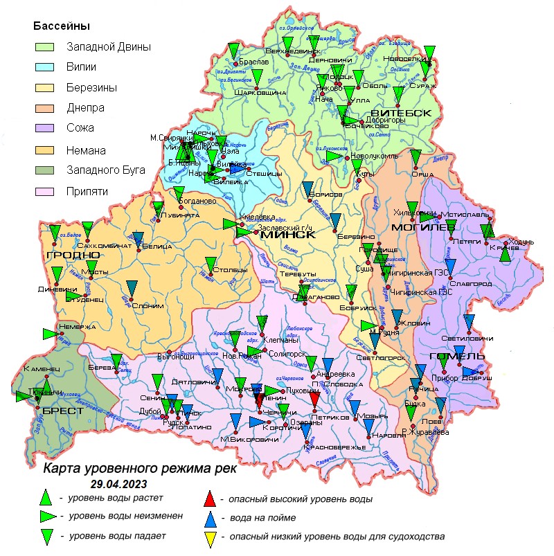
29.04.2023
Overview of hydrological situation of April 29, 2023
In the past day on the Dnieper near the town of Loev, the water level has dropped below a dangerously high level.
As of April 29 , the water levels of the spring flood continue to decline on the rivers of the country with a daily intensity of up to 39 cm .
Water levels exceed the water outlet marks on the floodplain on the Neman at ag. Belitsa, Vilii u ag. Steshitsy, Dnieper on the Zhlobin – Loev section, Berezina near Borisov, Berezino and Svetlogorsk, Sozh on the Slavgorod – Gomel section, some of their tributaries, on the Pripyat on the Chernichi – Narovlya section, as well as most of its tributaries.
Water levels exceed dangerously high levels in Pripyat at the village of Chernichi and the town of Petrikov.
According to the Ministry of Emergency Situations, river flooding is observed in most districts of the Gomel region, the Vitebsk region of the Vitebsk region, the Luninetsky district of the Brest region and the Stolbtsovsky district of the Minsk region.
The water temperature in rivers and reservoirs ranges from 5.8 ° C to 15 ° C.
In the next five days, the decline in water levels on the rivers will continue, as a result, on the tributary of the Dnieper, the Ivnya-Bond canal at the village of Budka, Sozhe at the town of Slavgorod and its tributary the river Besed at the village of Svetilovichi water levels will drop below the water outlet marks on the floodplain.
When using the information reference to Belhydromet is obligatory
 Official heraldic symbols of the Republic of belarus
 Internet portal of the President of the Republic of Belarus
 National legal Internet portal of the Republic of Belarus
 Ministry of natural resources and environmental protection of the Republic of Belarus