


Overview of hydrological situation of August 31, 2026
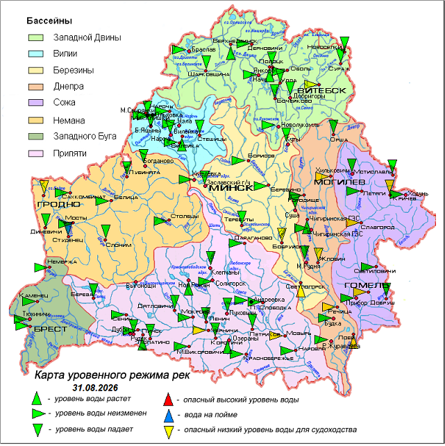
As of August 31, on most rivers a decline (1–5 cm per day) in water levels and their steady course are observed; only on the Western Dvina in the section Polotsk – Verkhnedvinsk, on the Dnieper near the urban settlement of Loyev, on the Berezina near Svetlogorsk, and on the Pripyat near Pinsk is a slight rise in water levels noted.
Water levels are below the marks limiting navigation on the Western Dvina near Vitebsk, the Neman near Grodno, the Dnieper near Mogilev, Zhlobin, Rechitsa and the urban settlement of Loyev, the Berezina near Bobruisk and Svetlogorsk, the Sozh near Krichev, Slavgorod and Gomel, and the Pripyat near the village of Chernichi and Mozyr.
On the Ross River, a tributary of the Neman, near the village of Studenets, the water level exceeds the mark of water outflow onto the floodplain.
Water temperature in the rivers ranges from 12°C to 22°C, and in reservoirs from 17°C to 20°C.
In the coming days, on most of the country's rivers the decline in water levels will continue.
When using the information a reference to Belhydromet is obligatory
Specialized sites
Informational resources
 State Symbols of the Republic of Belarus
 The National Legal Internet Portal of the Republic of Belarus
 The Ministry of Natural Resources and Environmental Protection of the Republic of Belarus
 The Official Internet Portal of the President of the Republic of Belarus
 The Portal for Rating Assessment of the Quality of Services Provided by Organizations in the Republic of Belarus
 The CIS Interstate Council for Hydrometeorology (CIS ICH)
 Information Analysis Portal of the Union State
 The Union State Committee on Hydrometeorology and Environmental Contamination Monitoring
 The Internet Portal "The Youth of Belarus"