


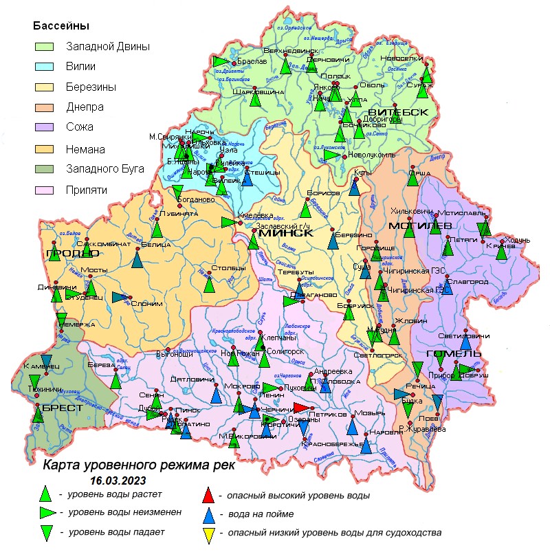
16.03.2023
Overview of hydrological situation of March 16, 2023
In the past day, the Sozh in the area of Krichev and the tributary of the Zapadnaya Dvina, the Usvyacha river, were opened, an ice drift is noted here. The Berezina basin and Lake Chervonoye were completely cleared of ice formations.
As of March 16, glaciation and glaciation with polynyas is observed on the Zapadnaya Dvina near the town of Surazh and settlement Ulla, its tributaries of the Obol, Polota and Drysa rivers, water on ice is everywhere noted, in places the ice has lifted. Ice formations and residual formations are noted in certain sections of the Zapadnaya Dvina, the Dnieper near Zhlobin, Sozh near Slavgorod, its tributaries the Oster, Besed rivers and the Pripyat tributary the Ptich river. Glaciation is noted on lakes and reservoirs, glaciation with polynyas, edges and divorces, the ice has a loose heterogeneous structure – it is extremely dangerous to go out on the ice!
There is an increase in water levels on the rivers, its intensity has increased and is 1-82 cm per day. The water is located on the floodplain on most rivers of the Pripyat basin, some rivers of the Neman, Vilia, Zapadny Bug, Dnieper, Berezina and Sozh basins.
In Pripyat, near the town of Petrikov, the water level exceeds a dangerously high mark. Water levels are close to dangerously high levels on the Pripyat near the village of Chernichi, its tributaries the rivers Sluch near settlement Lenin, Ptich at the village of Pershaya Slobodka and the Sozh tributary of the Pronya river at the village Letyagi.
River flooding persists in a number of districts of the Gomel region.
In the coming days, spring processes on water bodies will continue, the Dnieper river will be cleared of ice formations in the area of Mogilev. There will be an increase in water levels on the rivers, and therefore on the Berezina near Borisov and the tributaries of the Zapadny Bug to the Mukhavets river and the Sozh river Pronya, the water will reach the floodplain.
When using the information reference to Belhydromet is obligatory
 Official heraldic symbols of the Republic of belarus
 Internet portal of the President of the Republic of Belarus
 National legal Internet portal of the Republic of Belarus
 Ministry of natural resources and environmental protection of the Republic of Belarus