


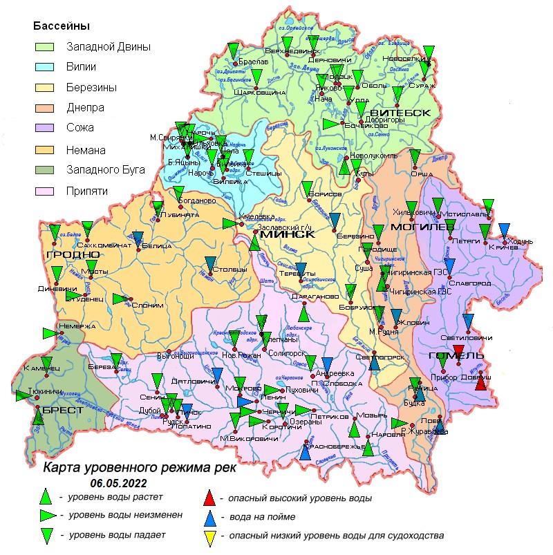
06.05.2022
Overview of hydrological situation of May 6, 2022
Over the past day, on the Sozh near the city of Krichev and its tributary, the Pronya River, water entered the channel.
As of May 6, on the rivers of the country, there is mainly a drop in water levels with an intensity of 1-34 cm per day. An increase in water levels is noted on the Dnieper in the Rechitsa-Loev section, Berezina near the city of Svetlogorsk, Pripyat in the Mozyr-Narovlya section, on its individual tributaries and the tributary of the Zapadny Bug, the Mukhavets river, but its intensity has decreased and is 1-14 cm per day.
The water is located on the floodplain on the Neman near the town of Stolbtsy and settlement Belitsa, Dnieper in the section Zhlobin - Loev, Berezina near the towns of Berezino and Svetlogorsk, its tributary the Svisloch river near the village of Terebuty, Sozh in the section Slavgorod - Gomel, its tributaries the rivers Oster near the village of Khodun, Besed near the settlement Svetilovichi and Iput near the city of Dobrush, tributaries of the Pripyat rivers Styr near the village of Lopatino, Tsna near the village of Dyatlovichi, Sluch near the settlement Lenin, Ubort at the village of Krasnoberezhye, Ptich at the village of P. Slobodka.
On the Sozh near the city of Gomel, the water level is 71 cm higher than the dangerous high mark, there is a drop in the water level with an intensity of 4 cm per day, on its tributary the Iput river near the town of Dobrush, the water level is 4 cm higher than the dangerous high mark, there is an increase water level with an intensity of 2 cm per day.
The water temperature in rivers and reservoirs has slightly increased and is in the range from 7,4°С to 15°С.
In the coming days, a decrease in water levels will be mainly observed on the rivers, as a result of which, on the Neman near the settlement Belitsa water will enter the channel. A slight increase in water levels will continue in the lower reaches of the Dnieper and Pripyat.
When using the information, reference to Belhydromet is obligatory
 Official heraldic symbols of the Republic of belarus
 Internet portal of the President of the Republic of Belarus
 National legal Internet portal of the Republic of Belarus
 Ministry of natural resources and environmental protection of the Republic of Belarus